
An amazing photo shows just how much of fragile Bribie Island has been carved away – and how much closer the sea has marched towards Golden Beach.
The image, captured by local resident Bruce Allender, portrays what’s left of Bribie’s old northern light tower, now surrounded by water.
A few years ago, the structure was perched at the top of the dunes and in the 1980s, it sat in the middle of the island.
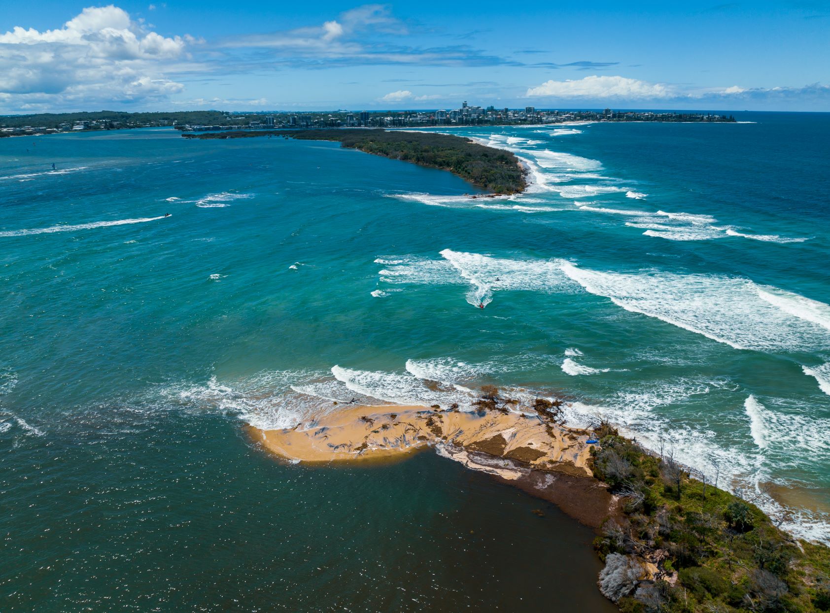
As covered by Sunshine Coast News, a new entrance to the Pumicestone Passage developed in dramatic fashion after a breakthrough in January.
In a matter of months, this opening, which has since been granted official coastal crossing status, has widened from 50m to more than 500m.
Persistent wild weather, including a recent large swell, has accelerated erosion in the area with a massive movement of sand and loss of trees, which have fallen into the passage and created hazards for boaties.
Mr Allender was collecting rubbish on the northern tip of Bribie Island’s southern isle with water and land care group, Night Eyes, when he saw the landmark being battered by waves.
“I was amazed. It looked pretty spectacular,” he said.
“We’d seen the light tower on the sand in the past, but on this occasion you would have to swim out to it.
“It was just out there in the water and it looked so lonely by itself.”
The tower was a key navigational point, mainly from the 1980s until 2018, for ships travelling to and from Brisbane. Ships are now guided by a solar-powered beacon 4km out to sea.
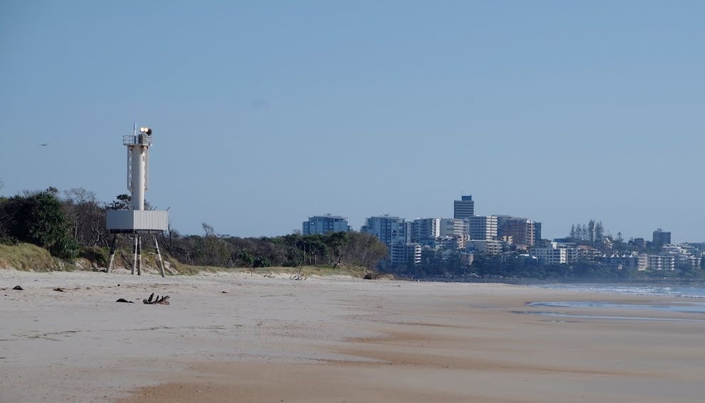
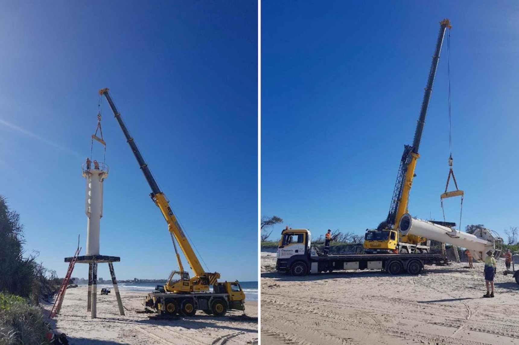
The light was taken away in 2018 and the platform, which is embedded in concrete among rocks, remains a well-known structure.
Mr Allender said nature was taking its course on and around the island, in stunning fashion.
“The level of change this season has far exceeded anything I’ve seen in the last few years,” he said.
“The Bribie shoreline has been receding for some time but it’s been super dramatic this season.
“It (change) is inevitable. It’s nature taking its course.
“We’ve had La Nina knocking us about and it (the erosion) is going to continue in some form as the island gets pushed further into the (Pumicestone) Passage.”
Mr Allender said there were “massive, old trees”, including pandanus, that had been washed from the island into the waterway.
“You’ve got to be careful in the passage, with the number of trees,” he said. “There’s an enormous amount.”
He said the breakthrough and associated wild weather had significantly impacted Golden Beach on the opposite side of the passage, largely because of the water movement and shifting sand leading to erosion.
“In some areas, it’s really chewing out the edge of the bank,” he said.
“It’s been a gradual process but it’s really obvious this year.
“And the passage looks very shallow, as the sand from Bribie is being pushed in.
“When La Nina goes away it will settle down but the channel has changed forever.”
Coast Guard Caloundra commander, Roger Pearce, said the recent swell had expanded the breakthrough, also known as the Bribie Island Bar and the South Bar, to about 550m.
He said the old light tower platform was about 25m off the island now.
“It (the breakthrough) opened up dramatically in the last two or three weeks with all that extra bad weather,” he said.
“There were 5m and 6m swells.
“We had a 6.5m wave the other day and we think it’s the fourth biggest wave we’ve had off Caloundra since records began. That’s decent surf.
“The old lead light tower is a well-known landmark and everybody has been watching it go further out during the last month or two.”
But it’s not going anywhere.
“The light stand is in bedrock. It’s been drilled and cemented into rock, so it’s not moving,” Mr Pearce said.
“Eventually, they will probably have to put a light on it.”
Mr Pearce also said the Bribie Bar was “unsafe” and “unpredictable”.
“I went across it last week and it was a nightmare trying to find safe passage out,” he said.
“It was swirling everywhere like a washing machine.
“The north bar (at Caloundra) is very stable, and you can just go straight out (at high tide) but we’ve been waiting for the south bar to settle, and it just hasn’t.”
Local resident John Groves, who has scribed 14 books on Caloundra and the Sunshine Coast, is compiling a book on the breakthrough and the island’s transformation.
He said the light tower “used to be in the middle of the island”.
“So, it shows you just how much the island has eroded away.”
Help keep fair, fast and FREE Sunshine Coast News coming by signing up for our free Daily News Feed: Please go to SUBSCRIBE at top of this article to register.
He said ships were first guided by a “big white board” on the island’s northern tip and a marker was upgraded from the 1950s onwards, with the tower in its prime in the 1980s.
“There was the board and then there was a tower, which we used to climb as kids, and they put a light on top of that. They went to Acetylene (gas) and then electricity,” he said.
“But because of erosion they stopped it.”
Clayton’s Towing removed the light in 2018, leaving the well-embedded platform.
